Research
Urban Heat Island
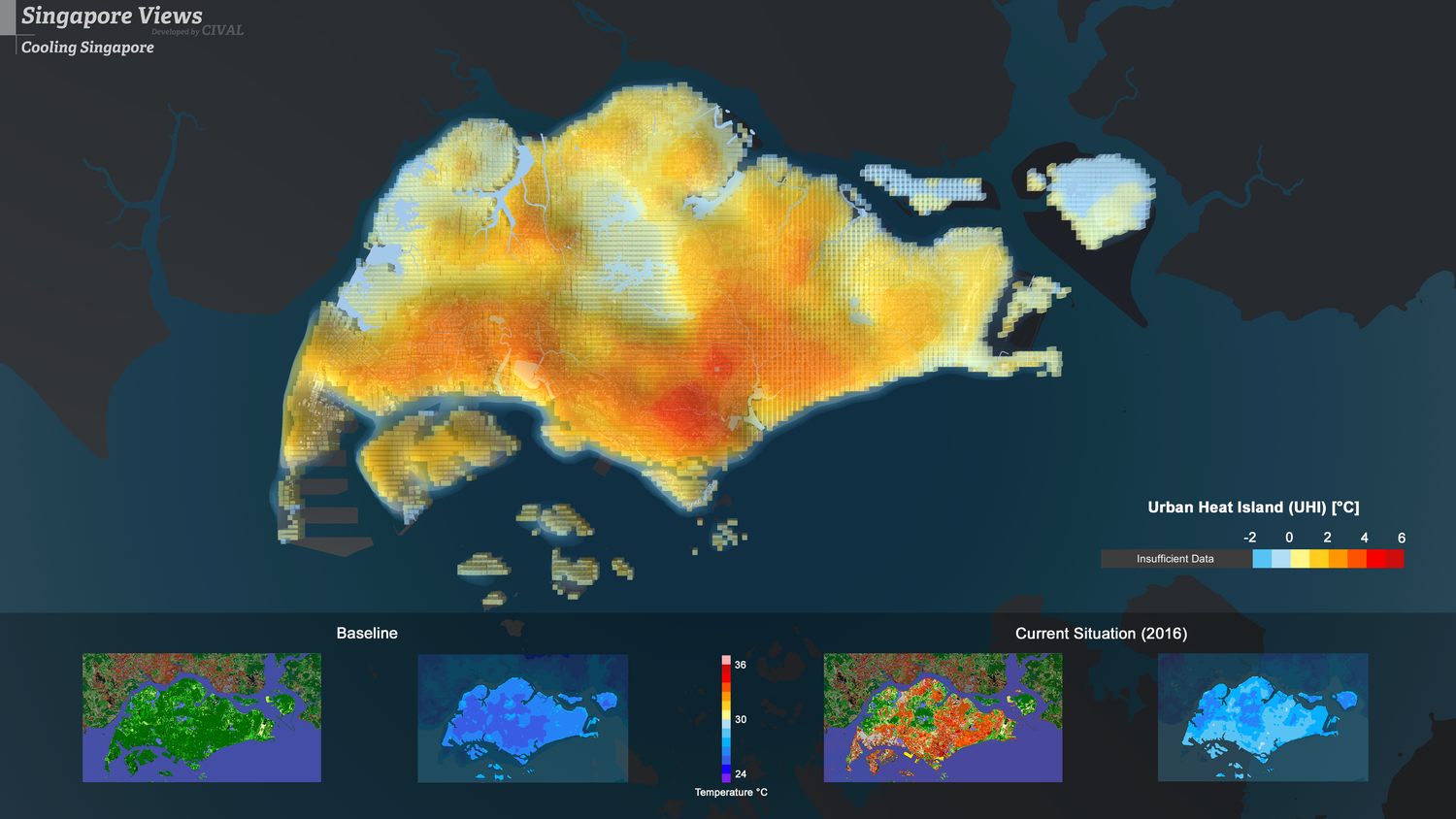
Cooling Singapore investigates Singapore’s Urban Heat Island (UHI) and plausible ways to mitigate the effect. The UHI effect is defined as the air temperature difference between rural and urban areas. It can help us to understand how urbanisation but also human behaviour are contributing to higher temperatures in the city.
To study Singapore’s UHI, Cooling Singapore makes extensive use of computational modelling approaches. The Weather Research and Forecasting (WRF) model is used to analyse the impact of UHI as well as potential UHI countermeasures to offset the effect in Singapore. Also, the Local Climate Zones scheme (developed by Stewart and Oke, 2012) is used to classify Singapore’s land cover in terms of surface structure (e.g., building/tree height and density) and surface cover (pervious vs. impervious). The UHI magnitude is measured by comparing the simulation results of the current urbanised condition (‘current-scenario’) with results of a plausible rural condition where all urban areas are replaced with vegetation (‘all-green scenario’).
The UHI effect shows a strong diurnal cycle, being low during the morning and building up considerably in the afternoon. The UHI effect in Singapore is the highest at night since the heat is trapped and stored in urban surfaces. The maximum UHI at night-time can reach around 4-7 °C in specific areas. Different countermeasures are currently being assessed.
Outdoor Thermal Comfort
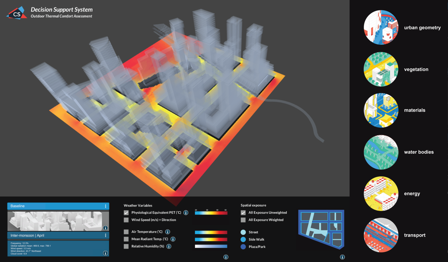
Cooling Singapore explores the impact of Singapore’s different microclimates and land uses on the Outdoor Thermal Comfort (OTC) of urban spaces. Each microclimate is composed of a set of atmospheric conditions (e.g., wind, humidity, temperature, radiation) with spatial and temporal variations. It can help us to understand the complex relationship between humans, climate, and urban spaces.
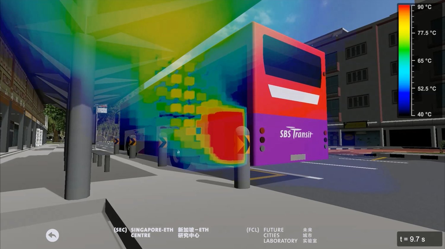
To assess the OTC, Cooling Singapore combines quantitative and qualitative approaches, such as computational fluid dynamics (CFD) modelling, on-site measurement with sensors, and survey campaigns. The project assesses passive and active strategies related to vegetation, urban form, surface materials, energy, and transport, in residential and mixed-use areas in Singapore. The impact of various heat mitigating strategies at district scale is being evaluated through annual reference weather types. Furthermore, an exposure process is being used to define the ‘importance’ or type of use of each location in space over time by users. The purpose is to better understand the impacts of the different measures, but also to help make better decisions where to invest in implementing specific strategies.
OTC is an important planning factor that needs to be considered in the early stages of design. Especially because it impacts people’s decisions on what outdoor spaces to use and what activities to perform. Singapore’s tropical climate requires specific attention to increase wind speed and reduce the incoming solar radiation (e.g., through void decks or elevated podiums). A decision support tool and climate-responsive guidelines are currently being developed.
Sankey Diagram
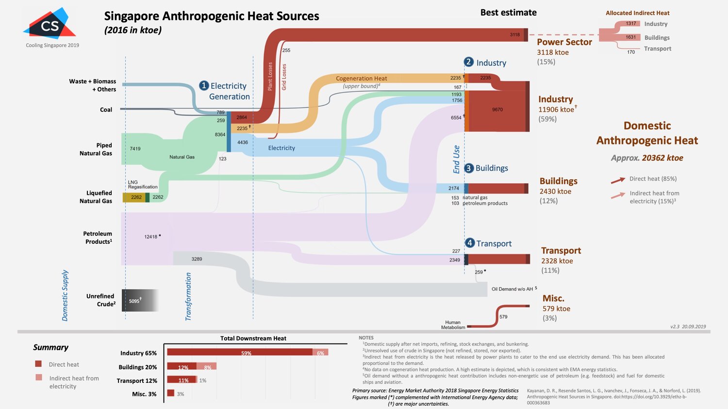
Cooling Singapore studies the main contributors of anthropogenic heat (AH) in Singapore. A Sankey diagram and a report have been produced to present the main sources of AH in Singapore and describe the definitions, assumptions, methods, and outstanding uncertainties considered.
The findings serve as the cornerstone of validating mathematical and physical approximations of the AH contributions in Singapore, as well as for analysing the impact of AH on the Urban Heat Island effect and the Outdoor Thermal Comfort. Data from the 2018 Singapore Energy Statistics of the Energy Market Authority was used. To get a more comprehensive understanding, an analysis of the country’s oil balance, supply of natural gas, power stations including cogeneration, and the industrial sector was conducted.
Cooling Singapore identified four major sources of AH in Singapore. Power plants (including the grid) emit 3,118 ktoe of heat (15.3%), while the three end use sectors: industry emits 11,906 ktoe (58.5%), buildings 2,430 ktoe (11.9%), and transport 2,328 ktoe (11.4%). Also, the heat released by human metabolism was estimated to contribute 579 ktoe (2.8%).
Digital Urban Climate Twin (DUCT)
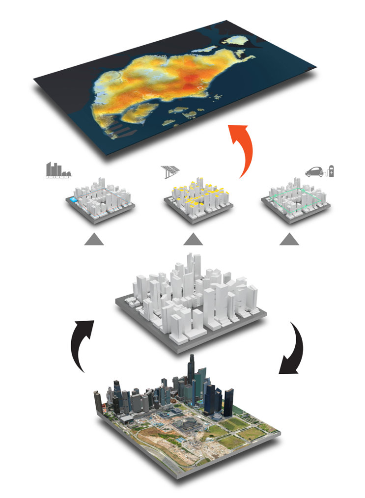
Cooling Singapore takes on an integrated approach to build a Digital Urban Climate Twin (DUCT) for Singapore to help urban planners, engineers and researchers weigh out the benefits and costs of various planning scenarios.
In order to take into account the multitude of factors involved in the planning of a built environment, DUCT aims to integrate all relevant model components, including computational models such as environmental, land surface, industrial, traffic, building energy as well as regional- and micro-scale climate models used in previous UHI and OTC research.
DUCT will be used to assess different cooling measures including innovative transportation systems, advanced building technologies, vegetation typologies, materials for buildings and pavements and climate-sensitive urban design solutions across spatial scales. The main benefit of the DUCT is the capability to simulate and evaluate holistic what-if scenarios. Developing this capability is crucial for the city planning agencies for robust climate-informed policy making in the future.
Climate Responsive Design Principles
Cooling Singapore assesses the impact of various urban design strategies on the outdoor thermal comfort (OTC) of urban spaces. The most effective implementation of climate-responsive design strategies is achieved using microclimate-specific and site-specific information. Ultimately, the goal is to provide new knowledge to planners in order to make more evidence-based design decisions in response to the climate conditions of an urban area.
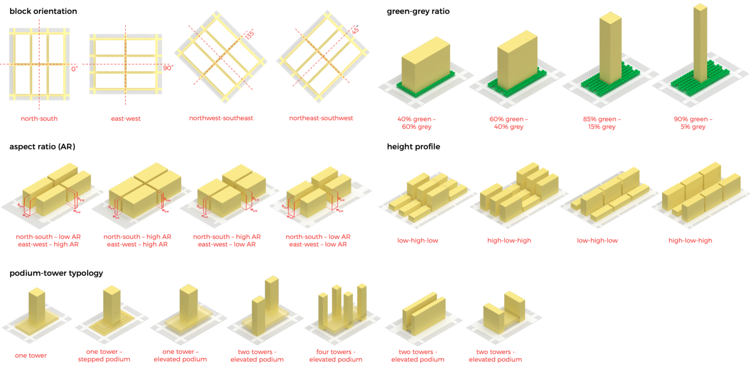
For the assessment of OTC, many climate, human, and urban variables come into play. The climate variables include air temperature, mean radiant temperature, relative humidity, wind speed, and wind direction. The human variables consist of level of activity (or metabolism) and type of clothing. Some of the urban variables are building and street orientation, aspect ratio (or building height - street width ratio), vegetation coverage, building height variation, building typologies, facade and pavement materials, and urban porosity.
Consequently, practical climate-responsive guidelines and principles to reduce the heat accumulation of urban environments are developed. These principles are results from a qualitative and quantitative analysis of computational fluid dynamics (CFD) simulations, on-site sensor measurements, and experts’ know-how. The analysis is based on a statistical framework, which incorporates concepts from climate science as well risk and decision theory.
Catalogue of Mitigation Stategies
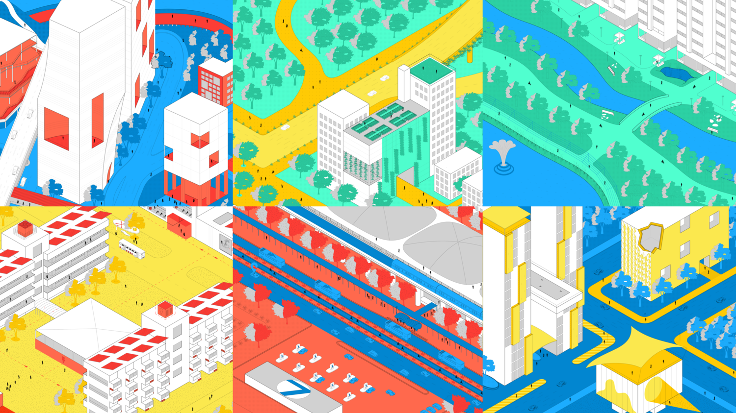
Urban Heat Island (UHI) and Outdoor Thermal Comfort (OTC) can be addressed through a myriad of strategies. Cooling Singapore identified potential strategies and measures for reducing the Urban Heat Island (UHI) and improving the Outdoor Thermal Comfort (OTC) in Singapore.
The project team developed a comprehensive catalogue that contains 86 measures, grouped in seven clusters: vegetation, urban geometry, water features and bodies, materials and surfaces, shading, transport, and energy. Each measure describes its impact towards UHI and OTC, its applicability in the tropical climate, its integration into urban planning, and its current research status. The content of the catalogue is based on literature review and expert knowledge from various perspectives on urban design, transport, energy, build construction, and urban climatology.
Guide of Simulation Tools
There are many tools available to assess Urban Heat Island (UHI) and Outdoor Thermal Comfort (OTC). The Cooling Singapore team developed a simplified guide of 24 simulation tools able to assess the impact of different strategies in reducing UHI and improving OTC in Singapore and similar local contexts.
The guide provides a description for each tool, useful links, and references, as well as a matrix to help users compare the features of the simulation tools. The tools are grouped into three categories based on the spatial scale and capabilities: microscale tools, mesoscale tools, and supporting tools. In particular, the microscale tools can study the interaction of buildings and neighbourhoods with their surrounding environment in the surface layer. While the mesoscale tools can assess the thermal environment from the city to a regional scale. The supporting tools are more strategy-specific (e.g., able to evaluate the energy performance of buildings) that can communicate through inputs and outputs with other tools. The content was collected through literature reviews and interviews with tool developers.
Urban Heat Vulnerability
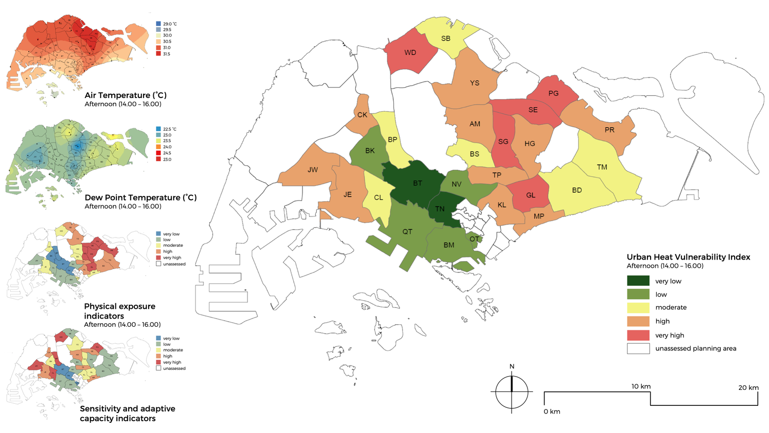
Cooling Singapore performs a spatio-temporal vulnerability analysis to identify areas of the city where heat exposure and sensitivity of the population are particularly high. The vulnerability analysis follows the latest definition of the International Panel on Climate Change (IPCC).
The UHV index (Urban Heat Vulnerability) is used to measure the effects of physical exposure, demographic sensitivity and socio-economic adjustment parameters. Physical exposure parameters such as: air temperature, humidity and vegetation coverage were examined. Also, socio-economic adaptive capacity parameters such as: age, unemployment, outdoor occupation, and accessibility to medical services and air-conditioned facilities were considered. The various parameters were equally weighted and spatially overlaid to determine the respective levels of risk of an urban area. A total of 28 planning areas were assessed, covering 98.8% of the population and 44 % of Singapore’s land area.
The areas with high UHV are defined as risk areas or hotspots. As a result of the vulnerability analysis, the planning areas are summarized into three hotspots in the coolest hour of the day (at 7 am) and five hotspots in the hottest hours of the day (from 2 pm to 4 pm). The findings help to define areas where heat mitigation measures are needed most, in order to ensure the protection of the population.
Field Campaigns

Cooling Singapore is interested in the awareness, beliefs and attitudes of Singapore’s population towards climate change and Urban Heat Island mitigation. Through online and on-site survey campaigns, Cooling Singapore has gained insights into the willingness to pay for the implementation of certain heat mitigation strategies in Singapore. Also, the impact of different outdoor climatic exposures on the cognitive performance of vulnerable population are being analysed, such as the seniors. These insights will provide important information for the development of a district-scale to island-wide vulnerability map.
In parallel, Cooling Singapore uses a variety of mobile and fixed sensors to measure the microclimatic conditions at the local level (i.e., district), including air temperature and humidity, atmospheric pressure, wind speed and direction, precipitation, and globe temperature. Fixed sensors have been deployed at the CREATE campus, at the Pinnacle Duxton Park, along Robinson Road, and in Asia Square to study their microclimatic conditions. The analysis of these measurements allows to measure the outdoor thermal comfort and validate the effectiveness of potential cooling strategies at specific sites in Singapore.